I was hoping to make it up there last October, but weather and or commitments never allowed me to get there. I decided I was going to start looking for the perfect day, September of this year. Foliage season was what I hoped for but was not limiting myself to that. Well, the day came this past Saturday. I could not have hoped for any better of a day. The weather Gods have redeemed themselves for the few curve balls they've thrown me lately. ;-) I also invited my friend Bob to join me on this one, which he accepted.
Warning! This is long with too many photos. :)
I was happy to find these mountains in my Maine Hiking Guide with a one page map and descriptions of the trails. It also had directions to the trail heads. These along with my car's GPS got us right where we needed to be. The map below shows the trails we used.

The plan was to hike Tumbledown and Little Jackson. I wanted to ascend the Loop Trail and descend the Brook Trail so we would not have to back-track all the way to the Loop Trail. Which meant parking at the Brook Trail, trail-head, and doing a 1.3 mile road walk to the Loop Trail. Why descending the Little Jackson Tr. to the Little Jackson Connector, to the trail-head wasn't discussed I'll never know. But that would have became mute as the day progressed. More on that later.
We parked at the Brook Trail lot and headed off on our road walk. Which was quite pleasant and went fast.


We reached the Loop Trail trail-head in about 30 minutes.

This trail was chosen for the ascent because it sounded like fun. Straight up with scrambles, caves, and steel rungs. :D I think once it started the steady climb, you gained about 1200' in .5 miles. The first of many OMG moments was just off trail at this bog with a view of Tumbledown over the tress.

Next up was huge glacial erratic along side the trail. Which dwarfs Bob.

Shortly after the straight up began.

With the first of the views.

Next, the trail leveled out for a bit and opened up with a good view of Tumbledown West Peak and it's ledges.

In the next photo, I've shown basically the route of the Loop Trail. Still haven't figured out why it's called that. The "Straight The Heck Up Trail" is better suited. 8)

The next few photos is a series leading up to the "Fat Man's Misery" showing the steepness.


At the top of this steep climb is the "Fat Man's Misery". Which is a small cave you must squeeze through to get past. At that point, there's no way around. The next few photos are of said spot.


Bob about to do the squeeze. He removed his pack so it didn't count. ;-)

Nice view from the top of Fat Mans Misery.

About 50 yards from Fat Mans Misery you hit the Tumbledown Ridge Trail.

Great views on the way to West Peak.


The summit marker of West Peak.

Made Bob and I smile too! :)


From here we back-tracked on the Ridge Trail to what I assume is East Peak although it's not named on the map.


And finally a view of Tumble down Pond. That was just slightly disappointing as it was fairly murky water do to the lack of rain I assume.

Heading down to the pond.


Eventually making it down to the pond.


While at the pond, Bob and I discussed our next move. The plan was to continue on to Little Jackson but how was the question. I'd read 2 other reports that mentioned an old/unofficial trail that headed up to Little Jackson from Tumbledown Pond. The problem is I had no idea where it started from. The mapped trails were going to be pretty long and quite a bit out of the way. Using the Pond Link Trail to the Little Jackson Trail to the summit is about 2.5 miles, and it loses then regains some significant elevation. I looked at this hike on Google Earth and saw a pretty good bushwhack ledge route to Little Jackson. I mentioned this to Bob and he said he'd give it a try if I thought it would work. So we headed up the Parker Ridge Trail to a ledgey plateau east of the pond.

The colors of the alpine ground cover was amazing.

From here, I showed Bob my proposed route. The photo below show the ledges I wanted to head up.

I told Bob to hang tight while I checked it out. Even though there's a lot of ledge there, the wooded sections between was thick enough that I knew Bob wouldn't have liked it. He doesn't bushwhack. So when I returned I told him it was even too thick for me so I didn't want to do it. A little white lie. ;-) So it was going to have to be the long way. But not before a couple of pics.


Heading back for the Pond Link Trail.


The next leg of the journey.

Now here's where the hike took a bad turn, for Bob. When we were heading up to that last spot, Bob yelled out for me to hold up a minute. When he caught up to me he said he'd thought he pulled something in his thigh but what ever it was, passed and was fine. About a minute into the Pond Link Trail, it happened to him again and again quickly seemed fine. But 5 more minutes into it, he had to call it. He hasn't been able to get out more than once a month and the steep climb had done him in. He insisted I continue. I told him this was going to take at least 2 hours but he said he wasn't going to let me not continue because of him. He'd be fine relaxing by the pond. Thanks Bob. This is why I said in the beginning, had we decided to descend the Little Jackson Tr. to the Little Jackson Connector it wouldn't have mattered. I needed to go back to the pond to hook back up with Bob.
So off I went on my own for Little Jackson. The Pond Link Trail went through some beautiful hard birch glades.


It seem to be descending forever but finally I reached the Little Jackson Trail.


And this trail was through just as beautiful woods.


Which changed to mostly conifers at 3000'.

Shortly after this, popping out onto a ton of ledgey goodness.

Jackson Mountain.

Junction of the Little Jackson and Jackson Trails.


The hike to the summit over all the ledge was awesome.


Webb Lake

A bunch of Maine 4K's. 8)


The summit.

The views from Little Jackson.


When I was making my final approach to the summit I'd made the decision I was going to bushwhack back to the pond. It had taking me about an hour and a half to make the summit including a 10-15 minute break. I just couldn't make Bob wait that long. I was still taking some photos when I saw a couple head off pretty much directly for the pond. Ah haa, the trail I thought was there was my first thought. As quickly as I could, I headed over to where they dropped down. Sure enough, some cairns. They're small but you can see one in the middle of the photo below.

In just a few minutes, you can see how close I was getting to the pond.

With this good view of the pond, I tried to zoom in to see if I could see Bob.

There he is. Looks like he's getting impatient though. 8)

The rest of the trek down.


Only the last 8th of a mile was a little tough to follow. Mainly do to it heading in a couple directions. But as it turned out, I took the right path as I came out right next to this trail and sign.
I met up with Bob who was hanging out on the ledges next to the pond. He said his wait wasn't that bad and expected me to be much longer. I told him it would have been had I retraced my steps. And after a quick brake we were off on the last leg. Descending the Brook Trail.

Me and my shadow.


And Done!

Below is a map and Google Earth image of my tracks. You can see the significant elevation loss, then gain you have to do taking the Pond Link Trail , and Little Jackson Trail to Little Jackson.


I came away from this hike feeling as though I had hit the lottery. I headed to an area I'd never been to before, or anywhere near without getting lost. Even with a GPS, back-country roads can be tricky. The weather was exactly as forecast, absolutely spectacular! And to hit this at what I'd call peak foliage was the icing, on top of the icing, on the cake.
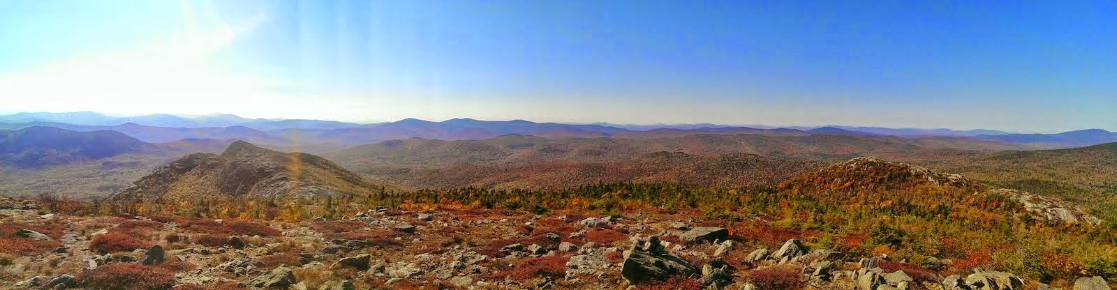
When Bob and I hit the open area at 2200' the superlatives, WOW!, OMG!, This is Surreal, starting flowing from our mouths and never stopped the rest of the day. Yes, it was that amazing.
The only reason we didn't discuss taking the Little Jackson Connector down was because it wasn't on my map. ;-)
ReplyDeleteAs for my impatience - it wasn't with you, it was from the chaos and noise from all the people hanging around the pond. What a zoo!
Whoa!
ReplyDeleteJoe, your narrative and super excellent photos certainly did justice to this gorgeous part of Maine. And I must admit that I'm a bit envious of you for hitting this area at peak foliage. There was color there when I visited last year, but NOTHING like what you experienced.
So far, Tumbledown still ranks at the top of my favorite hiking destinations! If I had to guess, it probably ranks high on your list of all time favorites as well.
Last but not least, thanks for including a link to my blog report regarding my Tumbledown hiking adventure.
John
Bob, it was great to have you along. I'd say I'm sorry I continued without you, but I'd be lying. ;-)
ReplyDeleteThanks for your comments John. That hike blew me away. I'll leave it at that. :-)
ReplyDeleteLooks like you had a perfect trip with weather and the foliage is looking good.
ReplyDeleteThanks. Yup, could not have been nicer.
ReplyDeleteThanks for this report - I hiked Tumbledown and Little Jackson today, using the Pond Link Trail. As I looked down on the pond, I wished that I could make a beeline for it instead of going back down the Jackson Trail. I did see cairns but couldn't get to them from where I was. Knowing there is a way, next time I will surely find it. I'm also wondering if there is a trail to the north peak. Certainly peeps must find a way to that huge slab ... it would be one awesome loop incorporating that. Lastly, like you I had never heard of this mountain until just recently ... definitely a hidden gem - and one that has been added to my list of trails to do multiple times annually
ReplyDeleteThanks. I was fortunate enough to see a couple of locals head down to the pond while I was on Little Jackson. I just followed their lead. If you look at the end of the second sentence in this report you'll see 1HappyHiker in green. Click on that. In his report it mentions a route to N. Peak Tumbledown.
ReplyDelete