Tuesday, October 21, 2014

Haystack Mtn., A.K.A., The Nubble 10/14/14

For the last day of our 4 day Columbus weekend, Becky and I parted ways. She just wanted to head home. It was a beautiful morning so I had to do something before heading home, no matter how short. I thought I might head to Crawford. Driving through there Saturday afternoon I spotted one of the many talus slides on the west face of Mt Webster. It's about .5 miles further north than Webster Slide. This is the spot. It looked like it would be easy to get to and not too steep. And should provide an interesting view of Crawford Notch.

But once there and pulled over at the side of the road, I decided I wanted something just a bit longer with more views. So my first thought was Mt. Oscar. Didn't like that idea so figured I'd just do The Sugarloafs. But before I made the turn onto Zealand Rd., I third choice was realized, Haystack Mtn. A.K.A., "The Nubble " I'd only been there once on the way to bagging PATN, Peak Above The Nubble. A.K.A. Unnamed Peak 3813. I didn't get to spend that much time there then.

So I drove to the gated and of Gale River Road and headed out.

In short order I was at the herd path / unofficial trail to Haystack Mtn.

Then my first glimpse of my target.

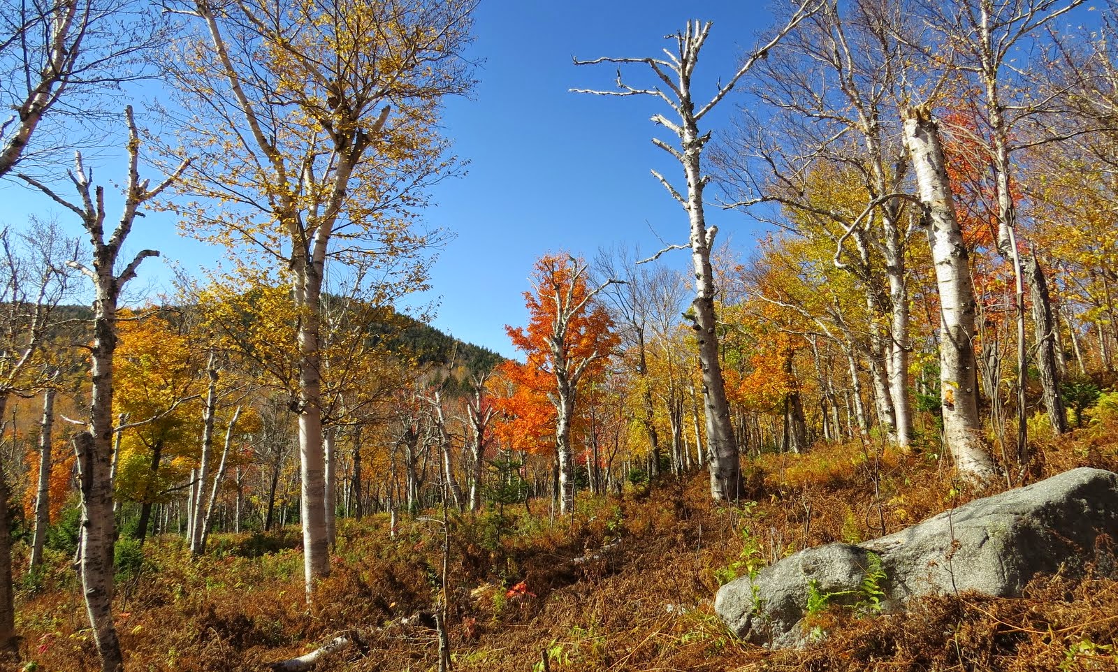
This trail is quite well defined as you can see below.

Which starts to parallel Haystack Brook for a ways. 
\

It eventually crosses Haystack Brook at this spot.

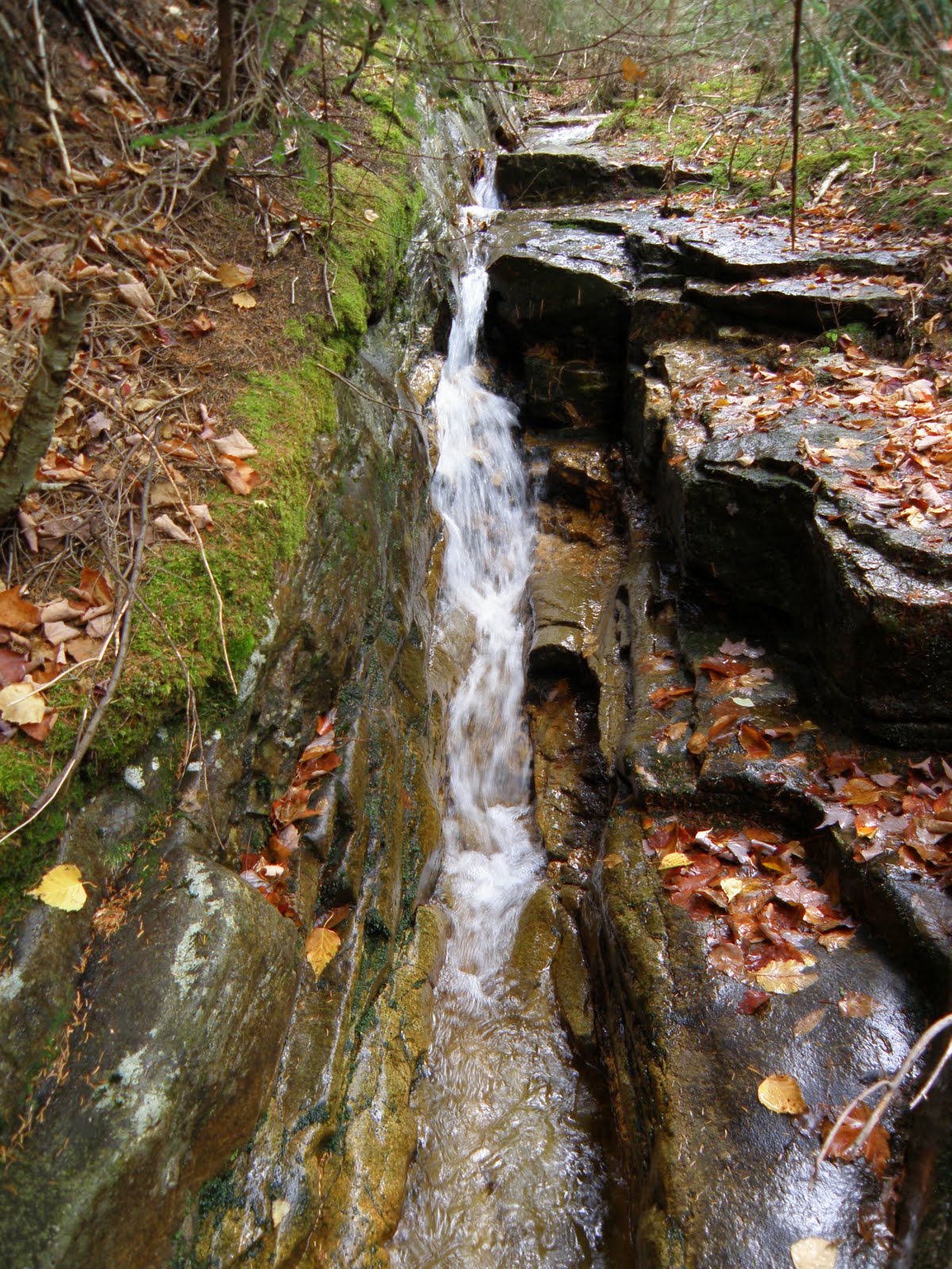
I could see that this ledgey section of the brook went up for a ways so I decided to follow it for a while. Word of caution: Wet leaves on mossy slabs = Wet Butt.  :(  It wasn't anything special but killed some more time.

Nearing the climb. See what I mean about the trail. Hard to miss.

And finally, the entrance to the ledges. 

The next several shots are the climb to the top.
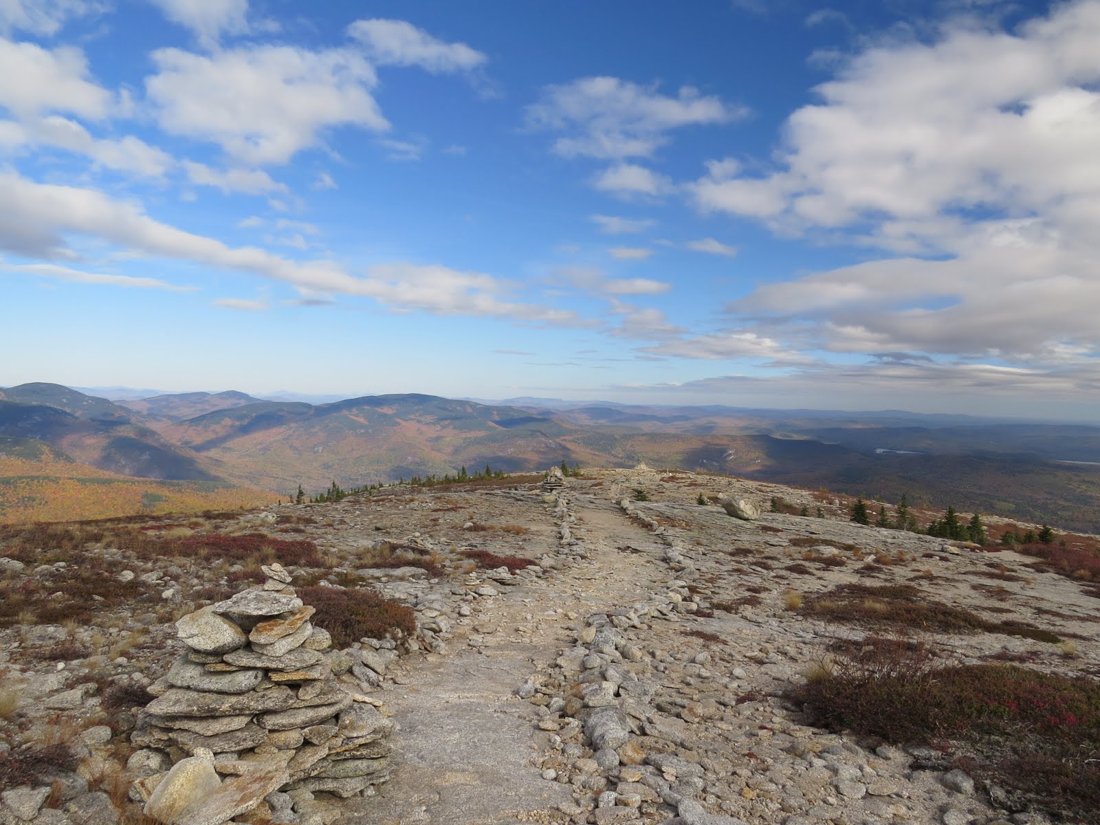
The summit.

Far more clouds were present on top than when I started out. But still, pretty descent views.
East

South 

West

Mounts Cleveland and Agassiz

Garfield making a brief appearance.

Presi's were once again a no show.  :(

In order, N. Sugarloaf, M. Sugarloaf, Mt. Oscar.

I spent well over an hour on top. Not a sole around, warm sun and a cool breeze. Could have sat there for hours. I relaxed first with the east view, then the west.

I did eventually have to go and the climb down was just as fun.

Back to the nice flat section of the trail.

I got to a point on the trail that I decided to shorten the return trip by cutting off a corner. Easy enough to do with nice open woods.

And .3 miles after back on the road, done. 

We had a great 4 days up north. Totally avoided the crowds. Both on the trails and on the road. Doing Saturday to Tuesday vs Friday to Monday was a, Grrreat,, decision. :D

The Tracks


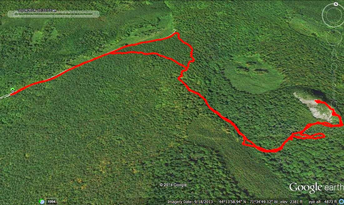
EDIT:  To better explain a comment by 1HappyHiker I've included a map and the Google Earth image of it. I shows, and better explains the brook and route I believe he is referring to.

The view form the slide if anyone is interested.
First, Haystack Brook higher up.

Near the top of the slide.


Monday, October 20, 2014

A different approach to South Baldface & Baldface Knob. 10/13/14

Monday 10/13 was the 3rd of 4 days Becky and I were up north staying in Intervale for Columbus weekend. We'd done a pretty long hike Tuesday so Becky was not up for much. I on the other hand was not up for something too short. Becky decided she wanted to hike Black Cap, and I decided I wanted to do some version of the Baldfaces. We had both cars with us for this very scenario. So we both headed up the road and turned onto Hurricane Mtn Rd. to do our perspective hikes.

On my drive to the Baldface Circle Trail, trail-head, I was giving some thought to what wanted to do. The plan I came up with was this. I'd take the Slippery Brook Trail to the junction with the Baldface Knob Trail. From there I'd bushwhack through some of the best birch glades out there to the col between Sable Mtn and South Baldface. From there I'd follow the abandoned Sable Mtn Trail (which you can read about HERE ) up the west ledges of  S. Baldface to the summit. Which can also been in the map below. Along with another area abandoned trail. The Baldface Trail.

Lastly from there I'd descend the Baldface Circle Trail to the Baldface Knob Trail, over Baldface Knob, back to the Slippery Brook Trail, and out. Just before reaching the trail-head I had a great view of the Baldfaces from Rt. 113.

Later than usual, 10:30 AM, I headed out on the Baldface Circle Trail.

Shortly after heading out on the trail I came across this little guy. Usually red squirrels let out  a quite loud alarm warning others, "stupid human approaching" 8) But this guy just froze.

It was a beautiful morning.

My first stop was Emerald Pool. I tried my darnedest not to stop since I got a late start but just couldn't pass. I never bother with the trail heading in, it's quicker and quite easy to just bushwhack in. Rather than go past it then backtrack on the spur trail to it.

Emerald Pool

I also like heading up just above Emerald Pool to a smaller but just as beautiful pool and cascade.

Now back to the trail.

The next leg of the journey would be on the Slippery Brook Trail. I really enjoy this trail as it's through beautiful woods.

3 miles later I was at my next leg. Here at the junction with the Baldface Knob Trail, you can see the a herb path just to the left of the sign just beyond those 2 logs. Here is where I'd start the bushwhack from.

It's not much of a bushwhack at first. 

Then it was into the beautiful glades and a great view of South Baldface.

No commentary here, I'll let the woods do the talking. :)

Sable Mtn.

Sorry, I guess I got carried away. ;-)  I've been in these glades twice before. Once in summer.

And once in early spring. I think I like fall the best. No, no plans to check it out in winter.  :)

OK, enough of the gorgeous woods, time for some climbing. First, I just needed to find some ledge to start out on. Check!

I was hoping to see moose in the glades, there was plenty of sign. This was the closest I came to that.

Now to find some signs of the old trail. Do cairns count? ;-)

With ledgey goodness comes views. :D Presi's in the clouds. :(
Sable Mtn. left. Kearsrge North center.

After finding the first cairn, it was pretty easy to follow. It did go through small stands of spruce but there were faint signs of the trail through them. 

And with that last bit of wooded trail, it was clear sailing to the summit.
North Baldface

Not much I can say about the summit of South Baldface. 

Next up the descent of the Baldface Circle Trail to the unnamed feature on the east ridge of S. Baldface.

There's some OK views from here as well. Moriah over Bicknell Ridge.

One more bump, excuse me, knob, to go. 
Baldface Knob with Eastman behind.

The summit of Baldface Knob.

And it's views.

It was around 2:30 now. I had roughly 3.8 miles to get back to the car. I set a goal of 4:00 PM to be back at the car. No reason for this other than the challenge. This would mean nonstop jogging where ever safe. I took break then headed out.

Eastman Mtn. and 2:44 PM. I thought I might hit that as well but decided I was ready for the hike to be over. Plus Becky, was waiting for me back at the hotel. 

Once off the Baldface Knob Trail, and past the steeper section of the Slippery Brook Trail, I was able to really start cruising. 3:11 PM.

Back to where the Baldface Circle Trail intersects with itself. 3:45 PM.

At the trail-head. 3:55 PM

And finally, in the parking lot. 3:56 PM  8)

The moral of the story.... There's no bad way to do any version of the "The Baldfaces".  :D

Tracks