Tuesday, September 22, 2015

Tortured and Broken on Whitewall Mtn. 9/18/15

As many know, I broke my ankle in April of this year. The ankle is coming along but still gives me issues with any aggressive walking. AKA, hiking. I was told it could be a year before I can't tell I'd broken my ankle.

But what many do not know is, I now have an issue with my left knee. The leg apposite the broken ankle. I'm not going to get into the whole story of how this injury came to be, but it was in directly related to the ankle. And, it happened at work. Long story short, I'm having minor surgery on it Thursday. I'm told it's usually 3 week rehab. Could be worse.

So I decided last Friday, and I have no idea why (I'll be saying this a lot), I should do one good hike before the surgery. Insert a huge, rolling eyes emoticon, here. I'll try and keep it as brief as possible how I ended up bushwhacking Whitewall. I had 2 plans. One was a very easy backpack to a spot I'd found years ago just outside the 1/4 mile restriction east of Thoreau Falls on the Ethan Pond Trail. I'd planned to go very light since the weather outlook was great. That would have been Fri. - Sat. The second was hiking the Rainbow Trail again via Bog Brook Tr. just to the height of land. Possibly further if I felt OK. I've been having PT for the knee for a month now and it's helped a lot. Someone wanted to join me on the Rainbow Ridge hike so that was the plan for Friday. Unfortunately he had to cancel last minute. I'd just driven to Jackson the week before and didn't really feel like doing the painstakingly slow ride on Rt. 16 again. I have no idea why. 8)  Having gotten up at 4, and found out my friend had canceled at 4:15, I really didn't want to start packing for an overnight then. What I decided to do was the overnight plan but as a day hike. Just hike to Thoreau Falls and back from the Zealand Tr.

Got to the trail-head at 8:00 AM and heading out.

I love the Zealand Trail for the most part but hate that rocky-rooty section that comes after the initial, railroad grade? I'm usually real cautious there because it always seems damp. But I was extremely cautious on this day.

That, finally after a 1/4 mile or so, gives way to easy walking again.

I was hoping to see some fall colors. I have found, pretty consistently, that Zealand Notch seems to be one of the places, for what ever reason, that starts to turn first. But only thing that was in it's fall garb was the hobblebush. 

Even though I was taking it easy, I reached the first views on trail soon enough. Just love this area.

The once "Z" bridge.

The view from it.

Looking back at Mt Tom.

I reached the junction with the A-Z Trail. 

Here, I had an epiphany (stupid idea). That was to bushwhack up Whitewall Mtn. Which,  I have no idea why, given my physical condition. Except for maybe remembering it was easy. So off I went. Pretty much on a moose herd path just after the small crossing. Looks pretty good.

On my last trip there in 2011, I'd found a good route on the descent. Whitewall has some outstanding birch glades. But what it also has is some killer hobblebush. I mean of the 6' tall variety. And since my 2 previous trips were in mid fall, I didn't realize it also has waist high ferns. Anyway, by staying just at the edge of the ridge before it drops off sharply, I'd found this in 2011. Looks like a trail.

Even though it was in the conifers, and not the beautiful glades, it was far easier walking. I have no idea why but I could not find that line. This may be a bad example of bad woods but those ferns are waist high hiding all sorts of hazards. 
I was running into all sorts of ugly woods. From pretty bad pencil woods to being forced into the man eating hobblebush. I took no pictures of the ugly woods. I recently bought a DSLR which is heavy and cumbersome. So why'd I take this very expensive camera on a bushwhack? I have no idea why.

I did eventually pop out for some air. 

I have no idea why, but I could not be happy with just heading to the main ledges. I wanted to head over to the top of the slide and work my way south. But that meant fighting through some very tough, thick, scrub. Basically straight that way.

But I made it. Twice at this spot but no nerve to climb down to where you can look down the slide. Finally, a bit of good sense. :)

From here, it still was not a cake walk to the larger open ledge. But here's some shots along the way.

Looking back.
A zoomed Zealand Hut
A mix of scrub and ledge along the way.

Found this lying flat so I sat it up. Good dog!  8)

Getting closer to the prize.

Bingo!

That was the lower of the large ledges. This is the upper. Same view but a little more open. 

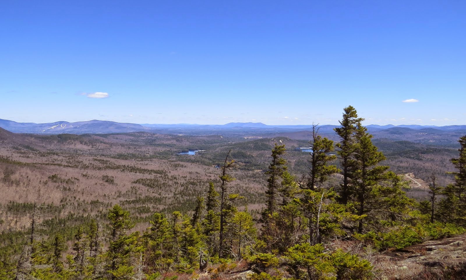
And few of the choice shots from here. Bonds, Guyot, Zealand, Hales.
Stairs, Resolution, Crawford and Parker Mtns. in center distance.
Field and Willey
The awesome 180* view.

Now I have no idea why since I'd done it twice, but I was going to head to the actual summit and sign the log. It's a pretty scrappy 1/4 mile trek. Luckily, I heard what I'm pretty sure was a bull moose grunting, out of site, in the direction I needed to go. No need to butt heads. I let out a couple yells and headed out, but away from the moose.

On the descent, as you see in the screen shot of my tracks, I fell or was forced by the woods, off the ridge a bit. In regaining it, I had a bit of an incident. First, something that I've suffering from for years is bad cramps on my inner thighs. These generally happen once ascending, or lifting my leg/legs up to get over something, during the second half of any given hike. Very debilitating. So while I was trying to regain the ridge, they started. Then, my right foot (yes, the broken one) got firmly wedged between 2 logs causing me to fall over. My still healing right ankle was pretty twisted. No pain though. But it was wedged so tight that lying down, I couldn't free it. I also, couldn't stand up. The cramps had set in real good now, and my left knee was toast. No strength at all. I managed to get my pack off to get to some mustard packets. These seem to work for the cramps fairly quickly about 60% of the time. So I lay there, underneath all the vegetation waiting and hoping for the cramps to subside,
watching my life pass by. Well not really  ;), but it was a scary few minutes. I finally manged to pull myself up by doing the hand over hand on a small spruce keeping me company. Got my foot unstuck and just sat for about 15 minutes. Then, recomposed, I headed down with still about a mile of whacking left.

Hears some shots of the lower glades I either passed though or went by. As you can see in the G.E. image, I was just outside the glades most of the time. You can tell that by the darker green I was in. These may look awesome but this whole bushwhack was a struggle, because of the woods.

Well, I did manage to get back on solid ground, but I'd gone through the entire 4 liters of fluids I had and 2 miles to go. I'd just finished the last 1/2 liter and wasn't really worried about that. Made a quick stop on the bridge at the northern end of Zealand Pond. I have no Idea why. I've dozens like it. :)

Now back to rocky-rooty. But this time, with absolutely no strength at all to deal with it. I really wanted to just sit down and stay there. Ahhh, 1 person may have missed me.  ;)

Practically crawling now.

And Done!

As many do, I to love to share my hiking experiences with others. But I wasn't going to this time. This is clearly something I should not have done, especially alone. This is the kind of stupid decision making you hear about novice hikers doing on Franconia Ridge.

So why am I telling this tale of monumental stupidity? I have no idea why! 

The route.


Wednesday, April 22, 2015

Surviving a Trek to Bald Mtn. (Chocorua) 4/19/15

This is a two part report so to speak. A sort of, before and after if you will.

PART 1....  The Before.

I was inspired to do this hike and short bushwhack last year after a report by 1HappyHiker. Which you can read about HERE . Which he, had been inspired by a report by Steve Smith. Somehow I had missed his report on this one. 

I'd had grander plans for Sunday but a couple of circumstances caused me to change my plans and almost had me out of the mood for hiking entirely. But After a good nights sleep Saturday, my less than enthusiastic attitude changed. While having my coffee Sunday morning, this hike dawned on me. Not much planning to do for this so I was out the door by 8:30. It was a gorgeous day and would have been a shame to waste it. In Part 2, you'll see that wasting it would have been the best choice.

I arrived at the trail-head by 10:30 AM and was soon heading out on the Hammond Tr.
One of the few places the trail sign is before the parking area. Which is rather small.

It was quite warm. First day of the year I was able to start in short sleeves. For the most part there was no snow at the lower elevation. But there was the occasional short stretch of snow and ice. 

But for the most part, wonderful bare ground. :)

At about .2 miles, you come to the first crossing of Stony Brook. There's a second at about .5. Neither were of much concern.
Small cascade on Stony Brook.

Shortly after the crossings of Stony Brook, I could see my target through the leafless hardwoods.

It had been I relatively flat walk but did start to climb fairly steeply. 

The trail eventually hits a couple switch-backs at about 1.3. Beautiful woods. I'm kind of sorry I didn't wait for the young spring leaves to come out. I love their lime green colors.

A around 1.5 miles, the trail hits ledge and the forest gives way to conifers.

Nearing the high point on this section of trail, more snow and ice started showing up.

It was this point, roughly 1.7 miles in, I took off to the east towards Bald Mtn.

Where I immediately encountered pockets of knee deep snow. 

In 1HppyHikers report he mentioned he found no text suggesting there was ever a trail that went to or over Bald Mountain. But once it hit ledge, I was seeing small cairns. Perhaps built by the many explorers that know of it's great views.

Now it was time to search out the views. The first spot I came to did not yield much in the way of views.

But I love these patterns formed in the granite,

Off to look for another spot with better views.

Ahhh, looks open down there.

Ossipee's
Green Mtn.
Chocorua Lake
Chocorua Lake with Grant Peak and the Mt Whittier Ski area in the Ossipee's above.

This was OK, but I know there's better. Moving along.

I knew from 1HappyHikers report that the best view was from atop a large rock. And I do believe that's it up ahead. 

I'd have to say, this is the spot. :)

Definitely the spot to kick back. The views from Chocorua are among the very best in the WMNF. But being in a spot like this, all by yourself without a sound to be heard, is indescribable.

Northerly views.

Moats and Kearsarge North.
Cranmore and Blackcap.

Super-zoomed Carter Dome & Mt Hight


I had one last ledge to check out. These are some shots along the way.

Ending here. A lot of similar shots, but I couldn't resist.

I even managed to spot Washington from here.

One last shot before heading down.

All good things must come to an end, so it was time to head down. On the way back to the Hammond Trail I passed this old campsite. Note the old, steel, milk crate. 

Back on trail.
Back to the switch-backs.
Back to the hardwood forest and where the dynamics of this hike changed drastically. 

PART 2.... The After.

After what, you are wondering. After, just beyond where you can see in the photo above, I slipped in the leaves and broke my ankle. That's right, broke my ankle. The grade steepens a bit just beyond the above photo. I stepped down with my left foot which slid out in front of me. My right foot which was just behind a small rock, stayed put. My body kept sliding down, my right leg bent up behind me. So contorted that my right foot was almost behind my head when I heard it. CRACK! I knew immediately from that, and the severe pain, I just broke my ankle. But, just to see how grave the situation was, I tried to stand up. Could not put even the slightest weight on my right foot. This is not good. I had another 1.2ish miles to go and not a soul around. First thing I did was to check if I had cell service. I did have a very strong signal. Second, was to take 5 ibuprofen. 1000 mg's. The pain was that bad. Next, I contemplated what to do. My decision was to try and get out on my own. It was 1:30 PM. Still time to make, "The Call" if I was not going to be able to do this. Once I knew this, I called Becky (dreaded this call more) to let her know what happened. I said she needed to get someone to come with her and head up. Even if I got out on my own, I wasn't sure I could drive. After the initial OMG's, she was on the move.

Now, how am I going to do this? The woods just off trail were open a blanked with leaves. I thought I could slowly butt crawl my way down. This just wasn't going to cut it. The woods looked open but I was getting hung up on everything from rocks to twigs. This would take hours. Time to dig into bag of goodies. Swiss Army Knife with saw blade, 15' of parachute cord, ace bandage, extra bandanna. I was lucky to be wearing my 8" tall, winter boots. I often still wear these this time of year, especially if a bushwhack is involved. I never took my boot off (not supposed to) but laced it even tighter. Then I cut a one foot splint. I rapped my leg just above the boot with the ace bandage, This was only for padding. Same goes for the bandanna. I then laced the splint to my boot and leg, extending the splint about an inch below my sole. My thinking was should I put my foot down, the stick would hit the ground first, supporting a lot of the weight. Didn't read that anywhere, it just came to me. And it actually worked pretty well. The padding was needed above the boot because I rapped that cord as tight as I could. Next, crutches. I looked around for saplings long and strong enough, that had a V. Found 2. Now if you've ever tried to snap a sapling, you'll know how important that saw blade was. So, about 45 minutes to an hour after the accident, I came up with this,

I had to move excruciatingly slow as to make absolute sure I didn't fall again, but this was working pretty good. No need to spoil anyone's beautiful Sunday afternoon. 8)

Even had time to take a picture or 2 on the way out. :)

There would be no rock hopping across Stony Brook on the way out. Gingerly, right through, was how I had to do it. On a break, a photo of my savior. ;-)

And three hours after the initial fall, I was out. And believe it or not, my armpits hurt more than my ankle at this point. 
And a little better look.

Once out, Becky was still 30 minutes away so I, maybe not so wisely, drove down to Ossipee to meet up with her. I'm very impatient. 


To some things up, a day I won't forget anytime soon.

My summit wonderings.


The morning after.

P. S. The punchline, minimum 8 weeks no hiking.  :(

AMENDMENT:   It dawned on me I should add something to this report. I did have a few items with me that made my self-rescue possible. But, an even more contributing factor is when and where this happened. 1.2 miles in, moderate to easy trail, plenty of daylight left, and a forest that gave me the tools I needed. Many more miles, a higher elevation, later in the day, difficult trail, etc, and I most likely would have had to initiate a rescue.