Monday, March 10, 2014

A Touch of Spring on Mt Chocorua. 3/8/14

With a pretty descent forecast for Saturday, I needed an easy (trailed) hike with great views. It took me all of about 5 minutes to pick Mt Chocorua. A major deciding fact was, I figured the Champney Falls Tr. to be a concrete sidewalk. Thus, making it easy to do this in just spikes and no need to carry the snowshoes. I desperately needed a light pack. I figured if I ran into a situation where I need the snowshoes, I'd just turn around. Ya Right! More on that later. ;-) This would be a few firsts for me. Mt Chocorua in winter. Hiking Chocorua via Champney Falls Trail. And finally, paying a visit to Pitcher and Champney Falls.

I got to the trail-head and headed out around 8, under cloudy skies. Weatherman gets me again. So I thought then.

The crossing over Champney Brook where the bridge is out, was welled bridged. :)

And the trail was as I had hoped it would be. Concrete.

The grades are great on this trail and the first mile and a half went pretty fast.

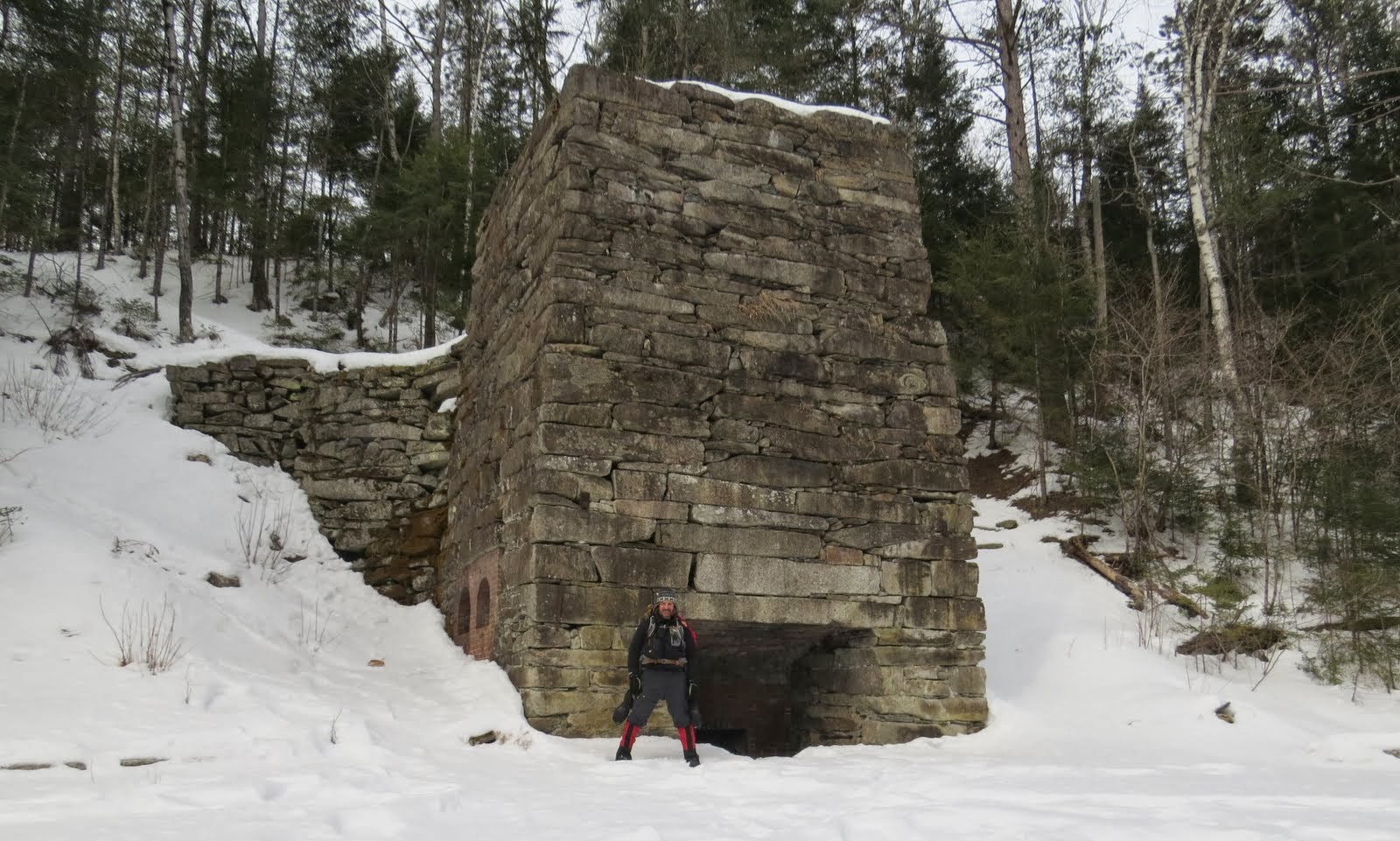
Arriving at the falls.

I assume this is Pitcher Falls. 

And this Champney Falls.

As I said I've never been there so I'm not exactly sure what is what in there. This is however a view from the top of the cascades.

Then onward and upward. I really like this trail. It's a beautiful area, and grades are very forgiving.

Somewhere in the 2500' range, give or take, the grades steepened a bit but the wonderful invention of the switchback, was well applied here. :) And at one point offered a sneak preview.

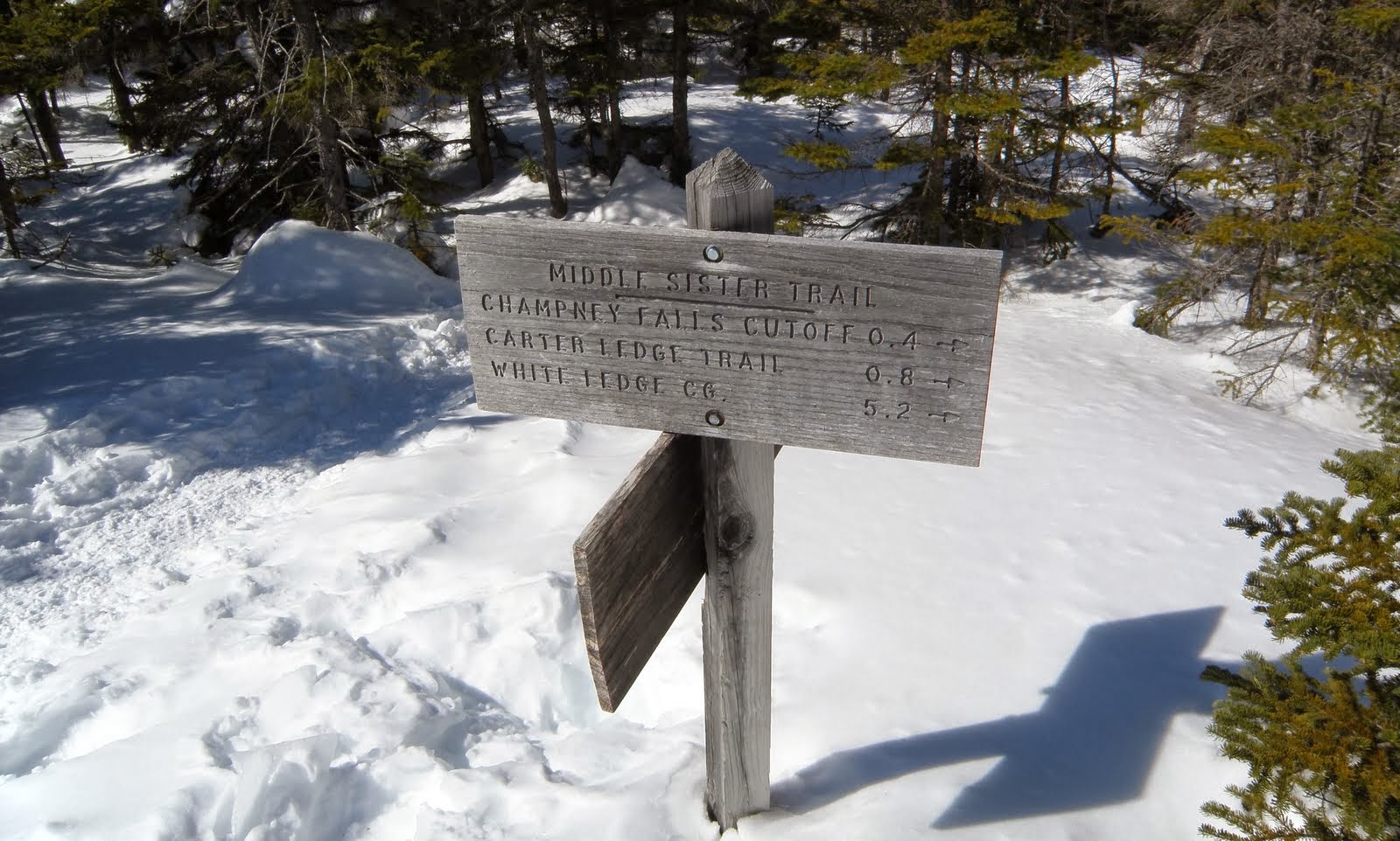
Somewhere in the area near the junction with the Middle Sister Tr. there was a beaten path to an open ledge with great northerly views. 

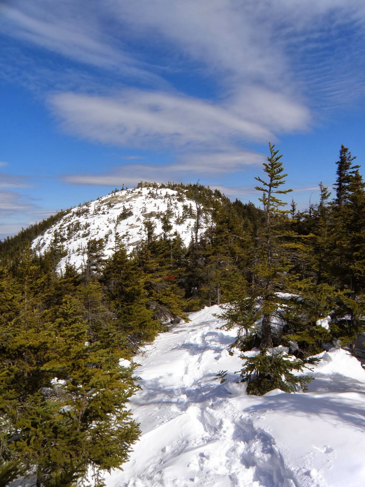
Back on trail I caught my first glimpse of Chocorua through the trees.

No need for words for a bit. 8)

Last bit of up.

Viola!!!

As you can see, the weatherman had redeemed himself. Had to be close to 40* and very little wind. Great views in all directions. Forgive the lack of labels. No patience for that today. But I think most of you don't need them.  ;-)


So how could I screw up such a great day, I'll bet you're asking yourself. Well, here's how. When I was passing the Champney Falls Cut-off to Middle Sister.....

I thought I'd hit Middle Sister first since the trail was in the same shape as Champney Falls Tr. But I decided I'd hit it on the way out. While on Chocorua, I asked a member of a group which route they had used to get up there because I was thinking of heading over to M. Sister. They had ascended the same way I did but had been over M. Sister twice this winter and should be well packed out. So I figured I'd head there. 

At the junction here, I could see it had seen use but nothing like what I'd been seeing all day.

I'd made it through the first wooded section only post holing a handful of times (remember, no snowshoes) and arrived at the scrambles up South Sister. The snow was pretty firm, not great, but holding my wait well enough. But as soon as I hit that small section of spruce mixed in the ledges, I fell in a spruce trap with both feet up to my waist about at the X. Here, is where I should have turned it around.


But did I? Au contraire! I battled my way to South Sister.
 Looking back towards Chocorua.

North

Heading down the ledges off S.S. wasn't too bad but once in the woods, in the col, it was real bad. Almost every step was at least knee deep. You can see the distance to M. Sister and the snow I had to deal with.

From the photo above to the scrambles up M. Sister took about a 20 minutes and I think it was only about 500 feet. I finally hit the ledges heading up M. Sister. About 20 feet up I hit my first waist deep pocket. Here, I finally folded. But the worse was yet to come. As I said earlier, the Champney Falls Cut-Off looked well packed out. Here it is on this end. No tracks at all. :(

This .3 mile trek took a half an hour. The first .2 was heavily drifted and every step was a post-hole to crotch. Unbelievably miserable. I couldn't figure out why one end was so packed and the other not at all. I found out why. About .1 mile in on the Champney Falls Trail side there's some open ledge that everyone must have been going to and turning around. 
Said ledge and views.

Well the great thing about the condition the Champney Falls trail was with it's easy grades, it was very jog-able. Heck, I was actually running at points and was back at the Falls in no time. And it was quite different now. These guys must now what they are doing but I saw good sized chunks of ice on the ground earlier and now it was pretty warm. 


The last mile and a half went just as fast as the previous from the cut-off trail. Saw another busy woodpecker on trail. 

And at 1:30, done. 

I, reeeally, do have to learn how fold them. But despite my little lapse in judgement, it was a great day to be out.  :-)


EDIT: Maybe someone can help me here. I've been referring to the sister I summit-ed as south, and the one I was headed to as middle. As I thought the fire tower remains was on middle. But after looking at a map, there's no significant bump north of what I'm calling middle. But the ledge off trail I hit was a significant bump. So is that off trail bump S. Sister?  And I could have continued up for quite a ways on open ledge. Could see that on G.E. So will the real 3 Sisters, please stand up. 

Wednesday, March 5, 2014

A Not So Sweet Bushwhack...Sugarloaf 3/1/14

This is the second winter in a row now that getting out hiking has been a problem. This winter has been even tougher. There has been many contributing factors. Family and heath issues have been a fair part of the problem. But I've had plenty of chances and the #1 problem has become laziness. Coupled finally with, a good 3 decades of day-tripping to the White Mtns for various reasons, I've grown very tired of the minimum 4 hour R.T. drive for one day. It's come down to a literal mental battle with myself every Friday weather or I'm going to head out, and what the heck am I going to do. It sounds like this should be the least of someones problem but after a 10 years now of almost never missing a weekend, the thought of slowly becoming aging coach potato is weighing heavy on my mind.

This past Friday night was no different. I did at least (slap myself)...thanks, I needed that 8), and pack a bag to head out in the morning. Where I was headed to, I had no idea. I did at least have a good half dozen ideas that I could go though while driving up. And to keep me placed firmly in  this rut I'm in, of coarse I chose the wrong one.

While on 93, and seeing pretty decent skies, I decided I'd finally do the bushwhack up Sugarloaf (Benton) then hike to Black since it ended up raining my only other time there. I got the Chippewa Trail parking around 7:30 and was on trail 15 minutes later.
 The Chippewa Train Maintained by my friend and hiking buddy, Mike Saltmarsh

As I made the turn south, I could see my first target. Sugarloaf Mtn

I wasn't sure where I wanted to start the bushwhack because when tested the snow in the woods near the parking area, I found it fairly deep there with 0 consolidation. So I decided to stay on trail for about a half mile to get some of the elevation gain done on trail.


It didn't end up being all that much gain, I believe I started just under 1300', and started the whack just over 1400'. I went in here. Sugarlorf, clearly visible.

It's tough to see in this photo but it was a moose super highway in there. I was sure I'd spot one today but did not. 
Tracks in all directions.

The woods were pretty decent.

But this is was I was dealing with, on every single step.

These open glades were stepper than they look. Every step I went in up to my knees. With the steep grade and deep snow, and the ice base-layer, it was like being on a treadmill. More often than not, I was stuck in place trying to move forward. I lost count of the times I said, "just turn around". Of coarse, I didn't.

Finally I thought I could see the summit at the top of these glades. Indicated by the sign of more spruce.

Nope, these glades which were steep in there own right, crested revealing the even steeper summit cone. :(
Having been a month since my last hike I was thoroughly wiped out already. Now I heading into even steeper, somewhat pencil woods. I thought this was going to have to be it for me. But while testing the waters so to speak I found to pluses to these woods. 1, the snow was about half the depth here. 2, there were plenty of trees to grab for assistance. Then finally a light at the end of the tunnel. I could see open ledge.

The first ledge I came to face north towards Black Mtn.

From there, I headed to the southern side to this but of ledge. With it's views.
Cardigan the tallest peak on the left.
Smarts, Cube, & Piermont tallest on left here.

Then the next towards the S.E.
Moosilauke, The Hogsback, & Jeffers

Then the last, and enough for me, a N.E. view.
North. Cabot & Waumbek on the distance horizon.
Cannon, The Kinsmans, with Franconia Ridge in the back.
Pano from that spot.

I was pretty disappointed overall in my views because this flat light makes for horrible photos, IMO. And I'd seen blue skies come and go in this, what seemed to be, endless journey to the summit. So after about 20 minutes of photographs, I headed down. I thought the descent, at least, would be easier. Not so much. 

Spotted this guy busy looking for a meal. Not sure of the type of woodpecker he was.

I diverted off my ascent tracks thinking following some drainage might have a bit solider, frozen ground and ran into this. The picture doesn't show it well, But there are a few dozen trees down here. Micro burst perhaps. Some above, and some beneath the snow. Navigating through them was a major pain in the A$$.

Finally did make it back to the trail. 

Believe it or not, I still headed up trail towards Black after all that. But that lasted all of about 5 minutes before I turned around. I did however, decide to check out the Lime Kilns.

The smaller and older kilns.
The large kiln. I'm there for scale.

You read about the history of these kilns HERE .

Time to get out of here. :)

Done!

To some up this trip: Don't pick a 2+ mile R.T.  steep bushwhack in deep, unconsolidated snow as you first hike in a month. And now I have 2 peaks on that ridge I need to return to on a much nicer day. Sugarloaf, and The Hogsback which I did about a year ago with the same weather conditions. Lastly, I should have gone with one of the trailed hikes I had in mind
 The tracks

The numbers. Note the stopped time. Much of which is me leaning on a tree questioning my sanity. :-)