I chose this hike because I wanted to return to Mt Bemis for the views from the meadow at about 3000'. That and the view from the old fire tower location. My first time there was on a rainy day 3 years ago.
This is a G.E image of the meadow. You can actually see the old trail. At least I assume that's it. It's in the right spot.

I decided to add Mt Nancy into the mix mainly just to go to the end of Norcross Pond. I love that spot. I had stellar views my first and only time on Nancy but thought I'd add that and do the only .7 mile whack to Bemis. I wanted to check out the pond in the col too.
I started out early, 6:45 boots on the Nancy Pond Trail.

The first 1.5 miles to the first crossing of Nancy Brook went fast. I was a bit worried that the rain on Friday may still have the brooks running high but there was no problem.

On the next section of trial there are a few of what I assume are logging artifacts.


Next, I came to a detour and reroute of the Nancy Pond Tr. My last time on this trail was May, of 2012. A section of the trail was completely wiped out by Irene. This reroute must have been quite the under taking.
The detour.

Next few photos are of the new section.


The last crossing of Nancy Brook is just below the cascades.

Now, Nancy Cascade.


The trail steepens greatly form the cascades to the height of land.
Once to the height of land, and several bog bridges later, I was at Nancy Pond.


Between Nancy and Norcross Pond there's a small pond and bog. There were dozens of these in the bog. No idea what they are but they looked cool.

Next up, Norcross Pond and the great view across it.

South Twin over the Shoal Pond Peaks

Now at the other end,.

And the fantastic view west from the outlet.

The Bonds and Franconia Ridge

The Twins, Hale, and Zealand.

OK, enough lounging, time for the 800' climb. Here's the start of the unofficial/illegal trail up Nancy.

I've heard people refer to this as a bushwhack. In no way, shape, or form does this resemble a bushwhack.


At one point you can either continue bushwhacking ;-), or climb a slide for about 100 yards. As I did the first time, I chose the slide.


From the slide to the summit it is very steep. But again, I've seen worse official trails to try to follow.

And now Nancy's summit.

And the view.


Now it was decision time. I saw nothing but bad woods from Nancy to Bemis. But I still tried to give it a go. I set out on 3 different routes to descend off Nancy. To make a long story short, ugly. Nothing but ugly looking woods. I'd have to descend nearly 500' and ascend 300' in horrible woods. At least as far as I could tell. It may have gotten better but I wasn't willing to find out. I also was thinking of forgetting Bemis. The thought of dropping back down to 1800' and starting over wasn't all that appealing. It was 11:00 AM. I set a time of reaching the fire-wardens trail of 1:00. If I got there by then, I'd give it a go. Well, I got there at 12:30. Game on. :(
The start of the fire-wardens trail is right after the first crossing of Nancy Brook. Technically it starts at Rt. 302 I suppose. At any rate, take a hard right after the crossing. Note: That's if you're ascending the Nancy Pond Tr. The downed birch crosses the entrance.

This sign had been torn down on Nancy. But I saw nothing of any new illegal trail work on either trail.

And as on Nancy, pretty easy to follow.


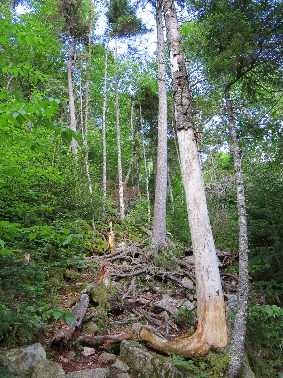
At about 3000' on the exposed east spur, the woods have really closed in on the trail. You really have to pay attention to the ground, sometimes pushing aside the young spruce. But the worst thing in that area is the blow-downs. A dozen or so to either climb over or crawl under.

I did lose the trial briefly in the blow-downs but was able to reacquire it quickly. The worst thing at this point was the toll the hike was taking on me. After climbing over and under all the blow-downs my legs were really starting to weaken. But even worse, cramp up. I knew I was close to the meadow so I wanted to get there before making any decision to call it. And in 15 minutes, I was there.


Absolutely gorgeous spot.

Now, again it was decision time. Be happy with this or go for the summit? I found a decent spot to sit a take a break. First, I ate 3 packets of mustard. I read it helps with cramps. I've tried it before and it does seem to work to an extent. I also had something to eat and drank close to 1 liter of Gatorade. Between the rest and fueling up, I was feeling much better so decided to go on. Of coarse all that was going through my mind was if I had sucked it up and down the whack I'd passed myself heading down by now. 8) So onward.
An old telegraph/telephone pole.


One more obstacle before the summit. And this was not there 3 years ago. The only way through, was through that hole.

And once through, more. :( Not to mention climbing the blow-downs set off the leg cramps again.

I did manage to make it to the tower but the true summit was totally out of the question. No matter how close it was.

With a decent seat here, I chose to sit for a while before checking out the views. But once I did, not to shabby.
Up Crawford Notch with Washington to the left.
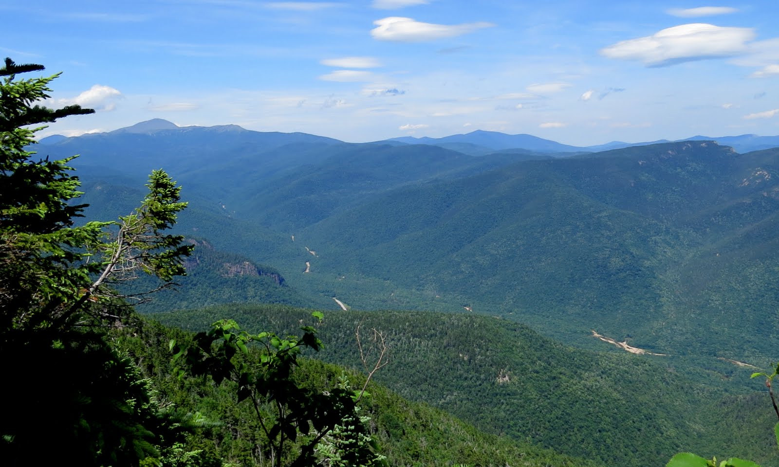
Crawford, Stairs, & Resolution

Attitash & Moats

It was around 3:00 PM now so I wanted to get moving. But I couldn't resist stopping for more photos at the meadow. I guess that's what you'd call it. It's basically a field of Sheep Laurel.


I hated to leave since there was a nice cool breeze and I just loved this spot. The breeze was prevalent most of the day. Which meant decent temps, no haze, and again, NO BUGS. I've been sooo lucky this year in that department. But I did have to move along. I lost the trail once again in the major blow-down area but still made to trail/road soon enough.

Being so wide with surprisingly good footing I started jogging. I reached the Nancy Pond Trail at 4:30. this was a 4 R.T.

I only had a mouthful or 2 out of 4 liters of Gatorade left so I filled a liter bottle and soaked my head at the crossing. I also stood, boots and all, at the foot of a small cascade and let the water run over my thighs. It's my adductor and or gracilis mustles that have been subject to bad cramping over the years. And I got one in each leg stepping over the last blow-down before getting back on trail. The cold water felt great.

Then it was an easy walking after the crossing.

And done.

To add to my increasing misery, both legs cramped severely trying to change my shoes at the car.
So, was it Nancy then Bemis the hard way? My legs right now are saying yes. Could I have done the bushwhack? Yes. But I'm sure the F bombs would be still echoing in the mountains. And that may have been even harder, who knows? But most objectives were obtained and I'm still here to write about it. Couldn't have been that bad. 8)
Here's the tracks. I'm putting this here just to show how close Bemis is to Nancy and how far I had to go to get there. 5 miles vs .7. Tough pill to swallow. :-)

Great report on a heck of a day, Joe! Thanks for sharing all the super view photos. Those blowdowns going up Bemis look truly miserable, definite cramp city. Still, you probably made the right choice. I remember the stretch from Bemis to the col with Nancy as one of the worst whacking areas I've been in, very dense with tons of blowdowns.
ReplyDeleteSteve
Thanks for your comments Steve. And thanks for the info. on the whack. I guess I ended up making the right call.
ReplyDeleteJoe
The right call would've been to call me! :P Great shots from Bemis, especially of Resolution and Stairs. I had no idea there were such open views from the tower area.
ReplyDeleteThanks Mike. I was pretty amazed at the views as well. Next time I will call. ;-)
ReplyDeleteJoe, you did a magnificent job of bagging Mt. Nancy and Mt. Bemis on the same day. I've done them both, but on separate trips. Your well-written report and fine photos brought back a flood of fond memories.
ReplyDeleteRegarding the current condition of the old Fire Warden's Trail to Mt Bemis, don't know how true it is, but was recently told that this old trail is deteriorating due to the death of the person who was stealthily/illegally doing light maintenance of this corridor. When using this route to hike to Mt. Bemis in July 2013, I noticed an obvious worsening of the trail as compared to earlier visits.
John
Thanks for your kind words John. As far as the trail goes, it has deteriorated significantly since my last visit in 2011. It was really tough to follow in a few spots past 3000'.
ReplyDelete