This hike was added to the list when I read this quote in a blog by Steve Smith. "I highly recommend this route to Carter Notch" He was referring to the Wildcat River Tr. In it, he describes a beautiful trail with the bonus of a slide to explore.
Another report, by an author I can't remember, was on the Rainbow Trail to Carter Dome. And what a great trail it was.
So the plan was to do a counter clockwise loop. Ascending Carter Dome first via the Rainbow Trail, making the short hike over to Mt. Hight for it's magnificent views, back over Carter Dome and down to the notch. Once there, playing around in The Ramparts for awhile, descending the Wildcat River Tr., checking out the slide, then finally out. A bit ambitious, but the only thing I didn't get to do at all, was hit Mt Hight. Which was decided for me by a totally socked in ridge. And I decided last minute to do this clockwise instead of counter. Feeling it would be better ascending the Carter/Moriah Tr. to Carter Dome than descending. Easier on the knees for me.
I started out on the Bog Brook Trail around 8:00 AM.
The trail was abundant in Lady Slipper.
I would have four of what you might call major brook or river crossings. None were that wide or deep. Now I'm not sure if there was a higher than normal level in all of them but none had an obvious place to cross. This is the first on which I believe is Wildcat Brook. On a side note, I'm labeling the crossings as best I can. I've looked the maps a couple times and am still not positive which body of water each crossing was.
More Lady Slipper.
The second crossing, a bit tricky again. Which on my maps is not named at all.
After .7 miles, I was at my first junction. Bog Brook Trail and the Wildcat River Trail.
Just walk with me. :-)
Bunchberry Blooms.
The third crossing which I think is Bog Brook. I know it looks innocent enough but again, I had to hunt for a place to cross. Of coarse, these crossings may have been easier had I brought my poles for stability.
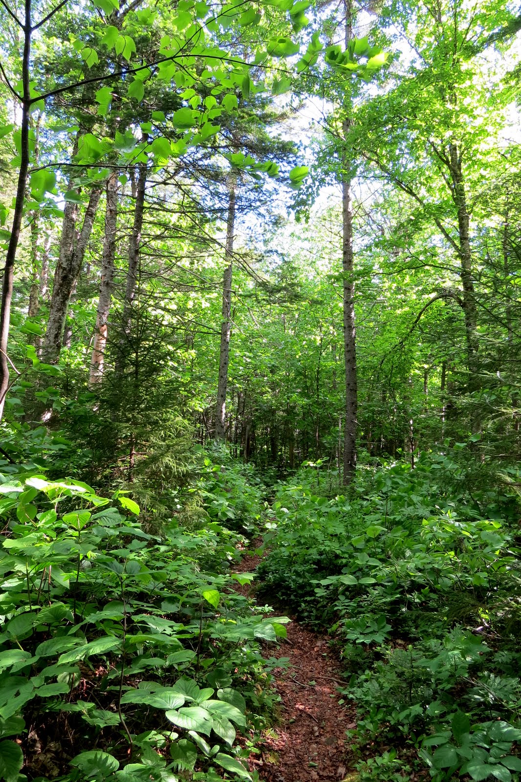
Let's walk some more on this beautiful trail.
I'm now at the junction of the Wildcat River Trail and Wild River Trail.
And now the last crossing, the Wildcat River.
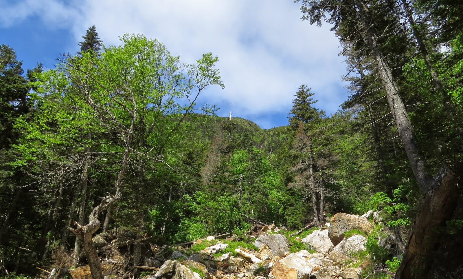
Skipping ahead about a mile, I came to the slide Steve Smith mentioned in his blog. Most likely caused by hurricane Irene. This was taken from the trail. The slide actually ran across the trail.
Very soon after starting up this slide, I realized I was not going to have the time I'd need to really go up very high. It was steep, with very lose footing. I could have gone off to the side and bushwhacked up higher but I was not seeing great woods there. So I probably only went up 100 yards or so. Just not enough time. It was still nice checking out what I did.
I'm guessing that's Wildcat B peak through the trees.
The view from as high as I went. Rainbow Ridge. Which I'd be seeing much later.
From the slide to Carter Notch, the trail steepened considerably.
But in relatively short order, I was at playground #2. The Ramparts.
This would be only my second time checking out the Ramparts. The first time I maneuvered my way up high enough to just get a view west out of the notch. This is from that day in which you can just see Madison.
Today I wanted to go even higher to see if I could see more of the northern Presi's. Something I've neglected to mention until now is the wind. The forecast predicted windy and that it was. From the star of the hike, even down low, the wind was whipping. Making for a totally, bug free hike. The in the Ramparts it was ridiculous. It was blowing so hard through the notch that trying to leap from boulder to boulder was not, a good idea. I could have literally blown me off my mark. There are some serious crevasses there and I didn't want to end up in one. Just getting to where I did and standing was tough enough.
The view east.
Time to move along. Going to skip the dialog here. Most have hiked from Carter Notch to Carter Dome. Some of the sites along the way.
After the steep climb, and the different view points, the Carter-Moriah Trail the rest of the way to Carter Dome is one of the most monotonous climbs in the Whites. IMO It just seems to go on forever. Before I got to Carter Dome I knew what I was in for, pea soup. Somewhere around the 4200' mark, I entered the clouds. :-(
I hung around for while hoping it would move off. Since I saw the occasional blue patch zip by at about 50 miles MPH. But I still had a fair amount of miles left so after having a sandwich, I headed off on the Rainbow Trail.
Already liking this trail.
Five minutes on this trail and this guy was strutting his stuff.
I'm not sure, but I think he just mooned me. 8)
So far, this has been a delightful trail and things are looking up.
Now I'd read that there were views from the trail but didn't know how good. It was looking more open than I'd expected.
How did this little gem stay off my radar for so long? And had I done this counter clockwise, I may have missed out on the views earlier.
Presi's over Wildcats.
Going higher.
Carter Dome and Mt. Hight.
Even higher.
Nice open southerly view.
Baldfaces.
Some trail!
As much as I'd love to stay here even longer, I still had about 5 miles to go. So it was time to move on. Still no complaints about this trail.
While still in the conifers, I spotted what seemed to be an open area 50 yards through these open spruce worth checking out.
When I thought I'd seen the most beautiful glades ever, another emerges to the top of the list. Or damned close to it.
Although the glades were worth the 15 minute walk I took in them, it wasn't really necessary. Since once back on trail, it goes right through gorgeous birch glades.
And to make my point about the "wild" side, I'm standing right on the trail here.
To say this trail is in dire need of a good brushing out is an understatement. One could argue to leave it as it is. Sure, it was a bit hard to follow but why spoil this.
At this point I thought I was so caught up in the beauty of the woods that I drifted off trail following a moose run instead. Apparently he thought it was a moose run as well. :D Score!
Well that was fun. My memory isn't what it used to be but I can't think of any trail I've been on that goes though such beautiful glades.
Down low it was just as beautiful, and could really use some brushing.
Yup, I'm on the trail.
I have to say this was one of the most gorgeous trails I've been on.
And finally a sign, Which had me a bit confused. I was expecting to see the Bog Brook Trail mentioned on it. Because the Wild River Tr. does cut back to the Wildcat River Tr. and then Carter Notch Rd. But that would be longer. I thought I missed a junction or there was a trail there I wasn't seeing. Once I pulled out the map, it was all explained.
Wild River trail just as nice.
And the next junction. The one I thought I was at before. Only 2.7 miles to go. 2.8 by the new maps. :-(
The next 2.1 miles of the Bog Brook Trail wasn't that great. It had some nice sections but for the most part it was a muck fest. Either do to no stones or bog bridges where they could use some. Or the fact that most of the bog bridges were in a state of disrepair. First off, it had to be rerouted around this beaver pond. And if not for some flagging, would have been real difficult to find.
And so and so forth to the next and last junction.
.7 miles to go.
A tad over 7 hours later, done!
It's been a while since I've explored so many miles of new trail on a hike. The Bog Brook Trail even though wet, was through nice woods. Wildcat River Trail, is a great route to Carter Notch. Beautiful woods. Even the short section of the Wild River Trail was very pleasant. But the gem of the day was the Rainbow Trail. Easy grades, great views, and woods to die for.
Two thumbs up for this great loop hike.
Glad you got to experience this - we checked it out last fall (Flags on the 48 weekend) and it was awesome! We also went CW, and that's how I'd recommend it. We took the FR to skip the crossings on the way in, and then hit them on the way out. In the fall, those glades were much easier to follow as a lot of the leaves were dying off, but what a cool trail! And a moose to boot. :)
ReplyDeleteThanks. Definitely a great trail.
ReplyDeleteJoe, you are a gifted storyteller and a fine photographer. This combo consistently makes your blog a very enjoyable read!
ReplyDeleteDid this loop several years ago (clockwise, just as you did). And yes, just as you state, the Wildcat River Trail is a terrific route to Carter Notch. I prefer this route over the Nineteen Mile Brook Trail.
Regarding the Rainbow Trail, totally agree that it's a true gem! Wish it was easier to access, but then again, it might lose some of its 'magic' if that were the case.
You got yet another remarkable photo of a moose! Perhaps being a "moose whisperer" is among your talents? :-)
John
Thanks so much for those very kind words John. It seems everyone who has done this loop or hiked these trails has the same opinion, "Fantastic"!
ReplyDeleteGreat Report Joe. This area has been on my bucket list for a while as well. Great pics......
ReplyDeleteThanks Mike. Trust me, it's worth it.
ReplyDeleteExcellent trip report, awesome photos! I'm going to have to check this one out for myself. Great find!
ReplyDeleteThanks. It was a great hike but I can not take credit for finding it. That was done long before me. ;-)
ReplyDeleteGreat report and photos on one of the coolest loops in the Whites. You really captured it beautifully, Joe! And what a unique experience, to be mooned by a Spruce Grouse!
ReplyDeleteSteve
Thanks Steve. It certainly does rank up there with the top loop hikes in the Whites. But had it not been for your report last summer, this one may never have caught my eye.
ReplyDelete